future of los angeles
reseda corridor
Before
After
REPORT
Suggested Citation
Alvarez, D., Ricardo de la Rosa, L., (2025) Future of Los Angeles: Reseda Corridor. Los Angeles, CA. Pacific Urbanism.
This report was featured in the Los Angeles Times article L.A. is under the gun to add housing units. The hard part? Where and how many
INTRODUCTION: CONTEXT AND PURPOSE
Los Angeles can build a future where housing growth strengthens the communities it serves. This study presents a framework to achieve that future—data‑driven, equitable, and grounded in the lived realities of the city. Using the Housing Allocation Index and the resulting Equitable Housing Allocation, we translate regional housing obligations into a clear, replicable plan for local action.
The analysis focuses on the combined Reseda–West Van Nuys and Northridge Community Plan Areas, which together form the study area. This combined area represents the housing and land use dynamics of the San Fernando Valley and is assigned an Equitable Housing Allocation (EHA) of 25,832 net new homes by 2029. Within this study area, Reseda serves as the primary case study, providing a tangible lens to illustrate how incremental, distributed growth can fulfill housing targets while preserving neighborhood integrity. The Equitable Land Use Plan developed for Reseda demonstrates how the EHA can be implemented in a way that is incremental, predictable, and socially sustainable, offering lessons that apply to Northridge and the broader Los Angeles context.
Our approach arises in a moment when Los Angeles neighborhoods have faced compounding pressures: families navigating long stretches of economic uncertainty, communities living with the risk of displacement, and residents enduring the cascading effects of public health crises and environmental challenges. These conditions have revealed the consequences of decades of underproduction and policy‑driven downzoning. Yet, even against this backdrop, the city retains the capacity to grow in ways that are fair, legible, and transformative.
The Reseda case shows how this is possible. Every parcel contributes: Accessory Dwelling Units behind single‑family homes, small fourplexes and bungalow courts woven into the neighborhood fabric, and modest corridor buildings that convert underused commercial sites into homes. Collectively, these incremental actions meet Reseda’s 13,885‑unit share of the EHA, while the combined Reseda‑Northridge study area achieves the full 25,832‑unit target without relying on speculative, site‑by‑site negotiations or disruptive mega‑projects. This dispersion‑as‑catalyst model reduces displacement risk, balances market pressure, and fulfills the state’s mandate to Affirmatively Further Fair Housing.
Ultimately, this study is about achieving Community‑Centered Outcomes—measurable improvements in people’s lives that flow from equitable housing planning: stable households, lower rent burdens, cleaner air, and cohesive neighborhoods. By linking rigorous spatial analysis to visible, incremental urban form, the Reseda‑Northridge study demonstrates that housing delivery can be technically sound, socially just, and deeply human.
HOUSING NEEDS AND ALLOCATION
Meeting Los Angeles’s housing needs requires aligning responsibility with capacity in a way that is transparent, equitable, and actionable. California’s 6th Cycle Regional Housing Needs Assessment (RHNA) obligates the city to plan for 456,643 new homes between 2021 and 2029, including approximately 184,000 units affordable to very low‑ and low‑income households. These targets are both a legal mandate and a moral commitment to provide housing opportunity while meeting the state’s requirement to affirmatively further fair housing (AFFH) under the Fair Housing Act and its implementing rule.
The Housing Allocation Index (HAI), developed by the Center for Pacific Urbanism, provides the foundation for translating citywide housing targets into an equitable, data‑driven framework. It evaluates all 35 Community Plan Areas (CPAs) in Los Angeles through five interrelated dimensions that capture both capacity and fairness. First, it considers transit accessibility, measuring proximity to frequent transit service and regional mobility options. Second, it incorporates neighborhood opportunity, reflecting access to jobs, quality schools, and essential services. Third, the HAI accounts for historic downzoning, quantifying the extent to which past land use policies reduced by‑right residential capacity. Fourth, it evaluates environmental health, using indicators of pollution burden, hazard exposure, and environmental justice to guide responsible growth. Finally, it assesses housing affordability, identifying areas with high rent burden, rising costs, and tenure instability. Together, these dimensions create a composite score for each CPA, revealing where housing growth can occur in a way that is both feasible and equitable.


Together, these layers identify both where growth is feasible and where growth is fair. Unlike past allocation methods that disproportionately concentrated new housing in already burdened neighborhoods, the HAI systematically aligns responsibility with opportunity and capacity, producing a quantified, replicable method for allocating Los Angeles’s RHNA target.
From this analysis, the combined Reseda–West Van Nuys and Northridge CPAs—treated as a single study area—receive an Equitable Housing Allocation (EHA) of 25,832 net new dwelling units by 2029. This figure represents the joint share of the citywide Regional Housing Needs Assessment (RHNA) target, derived from the HAI’s scoring framework, and reflects the area’s physical capacity, transit access, and role in advancing the state’s fair housing objectives (SCAG, 2021; CPU, 2024). Within the study area, approximately 13,885 units correspond to the Reseda–West Van Nuys CPA alone.


The Equitable Housing Allocation is implemented through the Equitable Land Use Plan (ELUP). This plan disperses the housing target across all residential land in the study area, ensuring that every parcel participates in meeting the housing need. By converting a numerical obligation into a visible, predictable urban form, the ELUP bridges policy, equity, and community outcomes. It provides a framework for fulfilling RHNA requirements, reducing displacement risk, and strengthening neighborhood continuity—demonstrating that housing delivery can be equitable, replicable, and socially sustainable.
LAND USE AND DENSITY TYPOLOGIES
Translating the combined Reseda–West Van Nuys and Northridge Equitable Housing Allocation (EHA) of 25,832 net new homes into physical reality requires a framework that is clear, defensible, and legible to both professionals and the public. The Equitable Land Use Plan (ELUP) provides this framework, connecting the numerical housing target to tangible urban form. It does so by modeling growth across all residentially designated parcels in the study area, rather than relying on singular “catalytic” sites. This approach reflects the principle that the catalyst for housing production is not a single building or project but the distributed participation of parcels across the study area.
The study area’s urban fabric consists of a mix of postwar single‑family neighborhoods, small multifamily blocks, and low‑rise commercial corridors that form the spine of Reseda and Northridge. Rather than disrupt this composition, the ELUP builds upon it, demonstrating that incremental and distributed growth can meet the combined EHA without erasing the character of existing neighborhoods.
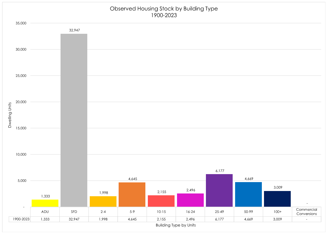

This analysis begins with parcel‑level GIS modeling, using Assessor data, zoning and land use layers. The typology distribution for the combined study area reflects both historical production trends and market feasibility. Of the 25,832 new units:
ADUs account for 3,616 units, of which approximately 2,295 are expected to be conversions of existing floor area, leaving 1,321 visible as new attached or detached units.
Transit Oriented Communities (100+ units) contribute 7,491 units, allocated to 159 commercial parcels based on the study area’s share of citywide RHNA.
Commercial conversions provide 2,067 units, leveraging 20% of the vacant office and retail floor area within the study area.
The remaining 12,658 units are distributed among 2‑ to 99‑unit building typologies, based on historic production patterns from 1960 to 1989—the period that produced the bulk of multifamily housing in the Valley. This results in approximately 937 units in 2‑4 DU buildings, 2,599 units in 5‑9 DU buildings, 1,253 units in 10‑15 DU buildings, 1,556 units in 16‑24 DU buildings, 3,711 units in 25‑49 DU buildings, and 2,601 units in 50‑99 DU buildings.
By combining this typology‑driven approach with 3D volumetric modeling, the ELUP demonstrates how incremental changes on thousands of parcels can cumulatively achieve the study area’s 2029 RHNA target. Each building type is represented by a standardized dwelling‑unit volume—1,000 cubic feet per unit—allowing the model to visualize not only unit counts but also the resulting urban massing. This approach makes the plan legible to policymakers and the public, as it shows how growth is distributed spatially and volumetrically without overwhelming any single block.

Building type density analysis for the City of Los Angeles. Figures above each bar correspond to the average observed Dwelling Unit per Acre for each building type (Example: A building with 2-4 dwelling units provides an average density of 16 dwelling units per acre)


STRATEGIC ZONING AND DEVELOPMENT APPROACH
The Equitable Land Use Plan (ELUP) translates the combined Reseda–West Van Nuys and Northridge Equitable Housing Allocation (EHA) of 25,832 net new homes into a practical and implementable development framework. Its core premise is that every residential parcel in the study area can contribute to meeting the housing target in proportion to its realistic capacity, creating a system that is predictable, democratic, and equitable.
Unlike traditional Los Angeles planning practices, which have historically relied on site‑by‑site entitlements, spot rezonings, and isolated large projects, the ELUP distributes growth across all residentially designated land. This approach reduces risk, simplifies administration, and fulfills housing obligations without triggering the political and economic bottlenecks of the old model. By enabling distributed participation, the ELUP transforms the 25,832‑unit target from an abstract obligation into a visible and achievable plan for local action.
The ELUP uses a lightweight overlay zoning framework to operationalize this strategy. Parcels that meet the overlay criteria automatically qualify for by‑right, ministerial approval for their assigned typology. This provides regulatory certainty for property owners, streamlines production timelines, and aligns with the state mandate to affirmatively further fair housing (AFFH) by dispersing growth across a wider geography. The overlay restores a unified land use regime that replaces the patchwork of discretionary processes, conditional approvals, and spot rezonings that have historically limited Los Angeles’s housing production.

Historical Trends and Projection of Housing Production by Building Type
To maintain construct validity and ensure the ELUP is grounded in realistic outcomes, growth modeling is based on probability‑weighted parcel participation. The results demonstrate that the study area’s EHA can be met through thousands of small, moderate, and occasional large contributions—without depending on speculative mega‑projects. This approach transforms housing production from a reactive, contested process into a predictable civic framework. By giving every parcel a role in achieving the community’s housing goals, the ELUP reinforces neighborhood stability, satisfies state housing mandates, and sets a replicable standard for community‑centered outcomes in Los Angeles.
visual analysis and data highlights
The combined Reseda–Northridge study area has an Equitable Housing Allocation (EHA) of 25,832 net new dwelling units, while Reseda–West Van Nuys alone accounts for 13,885 units of that total. The Equitable Land Use Plan (ELUP) translates these numbers into tangible, legible urban form, showing how incremental growth across the neighborhood fabric can satisfy the Regional Housing Needs Assessment (RHNA) requirements without erasing community character (California HCD, 2021; SCAG, 2021).
Using parcel‑level GIS modeling, the study evaluates every parcel in the combined area based on lot size, existing improvements, zoning, building footprints, and market feasibility. Each parcel is assigned to one of CPU’s eight residential typologies: from single‑unit parcels with ADUs to duplexes, fourplexes, bungalow courts, small walk‑ups, low mid‑rise apartments, and larger 50‑ to 99‑unit and 100+ unit developments in high‑intensity or transit‑oriented areas. Commercial conversions—repurposing underutilized office and retail floor area for housing—add another layer of production, creating homes without changing the street‑level appearance of these sites. By modeling probable development instead of theoretical maximums, the ELUP presents a realistic, replicable scenario for meeting housing obligations in both Reseda and the larger study area.
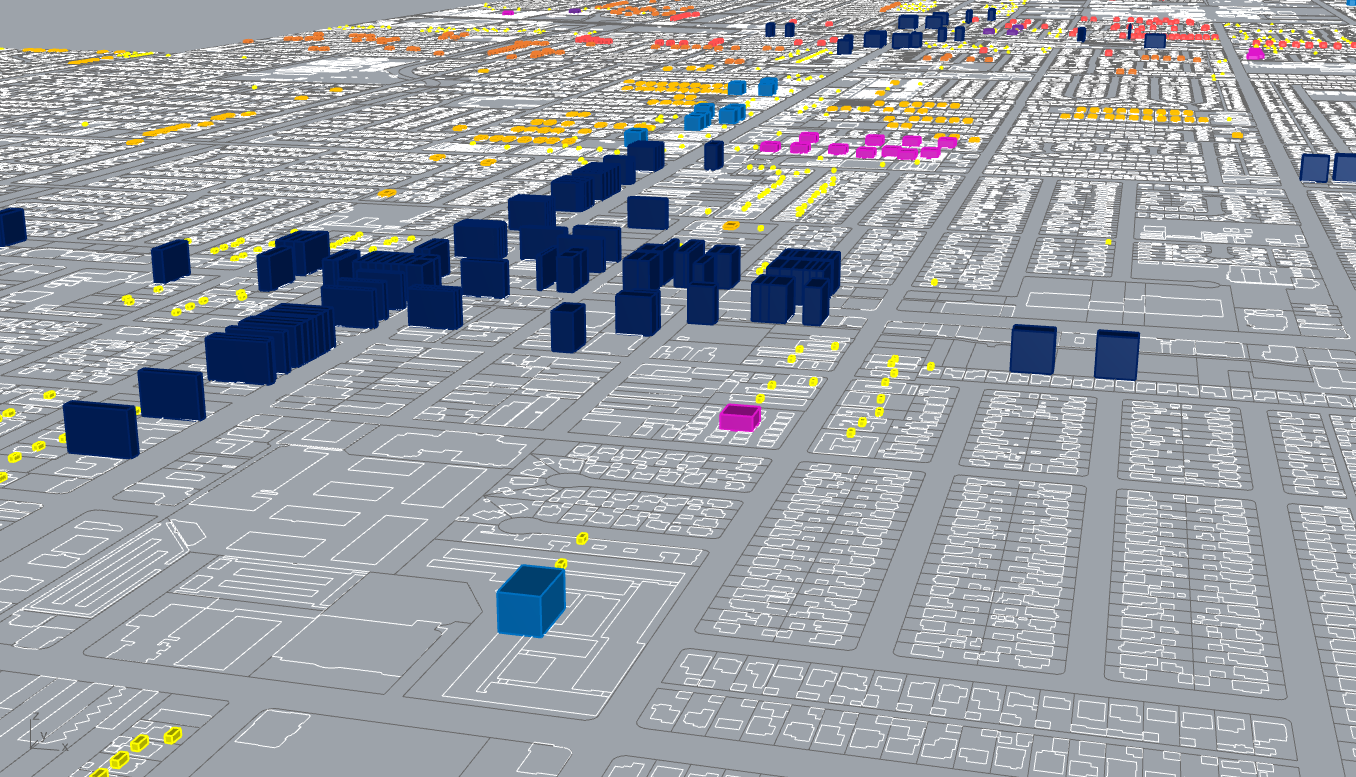
Quantitatively, the story is clear and consistent across scales. In Reseda alone, approximately 85 percent of the 13,885 units come from distributed low‑ and mid‑scale typologies: ADUs, duplexes, fourplexes, bungalow courts, small walk‑ups, and 5‑ to 24‑unit infill apartments. The remaining 15 percent is delivered through corridor development, commercial conversions, and select larger buildings, primarily along Reseda Boulevard and Sherman Way. In the combined Reseda–Northridge area, the same proportion holds true: roughly 21,900 of the 25,832 units (85%) are absorbed through small and moderate‑scale buildings, while the remaining 3,900 units (15%) come from commercial conversions and larger 50‑ to 100+ unit projects.


Equity is embedded in this visual and quantitative framework. By mapping the EHA against rent burden, tenure instability, environmental health, and transit access, the plan directs new affordable units to locations where they expand opportunity without triggering displacement. This pattern fulfills the state’s affirmatively furthering fair housing (AFFH) mandate while supporting community stability.
Together, the maps, visualizations, and data tell a compelling story: both Reseda and the larger Reseda–Northridge study area can meet their fair share of Los Angeles’s housing obligations through distributed, incremental growth. This approach produces a future that is visible, defensible, and replicable, proving that housing delivery can be technically rigorous, socially sustainable, and aligned with the principles of equity and Community‑Centered Outcomes.

EQUITY, CULTURE, AND COMMUNITY IMPACT
Los Angeles can meet its housing needs and strengthen its neighborhoods by aligning growth with the principles of equity and shared responsibility. In the combined Reseda–Northridge study area, 25,832 new homes are planned to be delivered by 2029, with 13,885 units in Reseda alone. These homes will be created through a distributed and incremental approach that turns every residential parcel into part of the solution, supported by clear data, careful modeling, and community‑aligned design.
By combining these elements, the ELUP produces what we call Community‑Centered Outcomes (CCOs). These outcomes are tangible and measurable:
Families staying in their neighborhoods with lower rent burdens.
Safer, cleaner streets and improved local air quality.
Economic resilience as new residents support small businesses and local services.
Neighborhood cohesion strengthened by growth that feels like a natural continuation of Los Angeles’s historic patterns.
Historical production patterns guide the distribution of building types, while affordability and displacement risk inform the placement of new units. By layering the Housing Allocation Index (HAI), Equitable Housing Allocation (EHA), and community metrics, the plan ensures that growth benefits are widely shared and clearly understood.
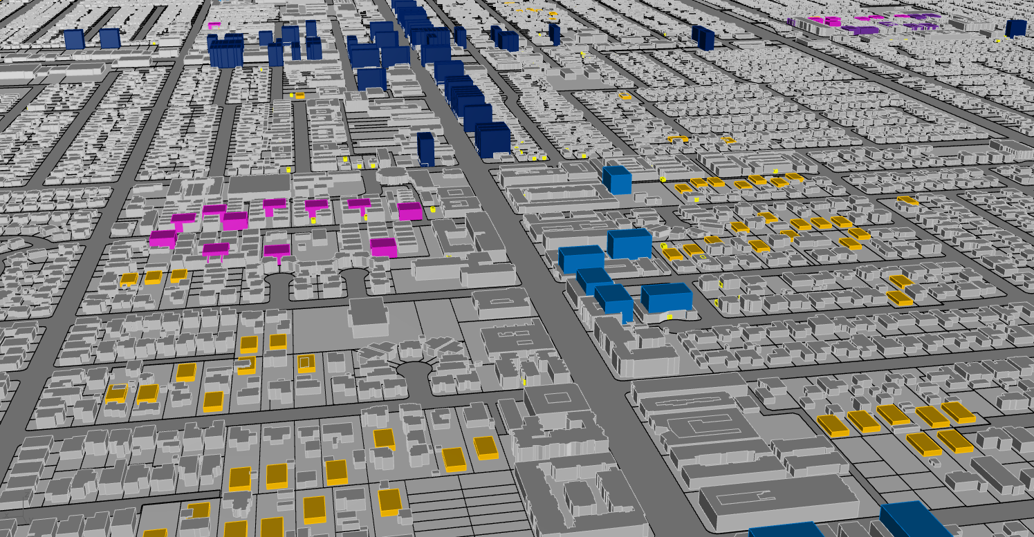
Most importantly, this plan moves from analysis to action. The incremental, distributed approach makes growth predictable and democratic: 85% of new units come from low‑ and mid‑scale development, while the remaining 15% is thoughtfully absorbed by commercial conversions and corridor buildings. Every home built contributes directly to stability, opportunity, and environmental health in the study area.

Visualization of equitable housing production along Chase St in Northridge
CONCLUSION AND AREAS FOR FURTHER RESEARCH
The Reseda–Northridge Housing Study demonstrates that Los Angeles can meet its housing obligations while strengthening, not sacrificing, the neighborhoods that define its character. By integrating the Housing Allocation Index (HAI), the Equitable Housing Allocation (EHA) of 25,832 units for the combined study area (including 13,885 units in Reseda), and the Equitable Land Use Plan (ELUP), this study provides clear evidence that the city can satisfy its Regional Housing Needs Assessment (RHNA) requirements while affirmatively furthering fair housing and advancing community integrity.
The central insight of this work is straightforward and transformative: the catalyst for housing is the system, not the site. By enabling distributed, incremental growth across all residential land, each parcel becomes a small but essential contributor to a collective solution. In the Reseda–Northridge study area, the majority of new homes emerge from ADUs, duplexes, fourplexes, bungalow courts, and small and mid‑scale apartment buildings. Moderate corridor infill and selective larger developments in high‑intensity districts provide additional capacity, creating a balanced and resilient production model. This approach delivers housing that is predictable, democratic, and scalable, without relying on speculative mega‑projects or politically vulnerable rezonings.

The implications of this work extend well beyond the Reseda–Northridge study area. The framework—built on data‑driven allocation, typology‑based modeling, and legible visualizations—can be applied to all 35 Community Plan Areas in Los Angeles and adapted to regional and state contexts. It offers a replicable paradigm for how cities can meet housing obligations in a way that balances policy, practice, and community benefit. In this model, growth is a shared civic act: every neighborhood participates, every resident benefits, and the city as a whole moves closer to a future defined by Community‑Centered Outcomes.
Areas for further research include integrating market response modeling to refine absorption rates; conducting longitudinal displacement and stability studies to monitor social outcomes; and developing immersive visualization tools, such as live massing dashboards and virtual reality experiences, to make equitable planning tangible for policymakers, stakeholders, and the public.
In the Reseda–Northridge area, this study proves that Los Angeles can build and belong at the same time. Through distributed, incremental, and equitable growth, the city can meet its RHNA goals, uphold its commitments to fair housing, and honor the promise of home for generations to come.
Bibliography
Alvarez, D., & Center for Pacific Urbanism. (2022). The Housing Allocation Index: A Framework For Equitable Housing Growth in Los Angeles. Center for Pacific Urbanism.
California Department of Housing and Community Development (HCD). (2021). 6th Cycle Regional Housing Needs Assessment and Housing Element Requirements. Retrieved from https://www.hcd.ca.gov/planning-and-community-development/rhna
Southern California Association of Governments (SCAG). (2021). Final RHNA Plan: 6th Cycle (2021–2029). Retrieved from https://scag.ca.gov/rhna